

A tornado warning was issued for Mayes and Rogues Counties in Oklahoma around 8:00 p.m.
Google’s Public Alert system issued the following warning:
A Tornado Warning remains in effect until 9:00 PM CDT for Northwestern Mayes and central Rogers counties. At 8:17 PM CDT, a confirmed tornado was located 4 miles northeast of Tiawah, moving northeast at 20 mph.
Hazard, damaging tornado and quarter size hail.
Source, weather spotters confirmed Tornado.
Impact: flying debris will be dangerous to those caught without shelter. Mobile Homes will be damaged or destroyed. Damage to roofs, Windows, and vehicles will occur. Tree damage is likely.
Locations in or near the path include: Pryor. Pryor Creek. Salina. Adair. Pensacola. Hoot Owl. Strang. Snowdale State Park. This includes Interstate 44 between mile markers 251 and 264. Tornado, observed hail, 1.00IN.
Recommended actions
To repeat, a tornado is on the ground. Take cover now! Move to a basement or an interior room on the lowest floor of a sturdy building. Avoid windows. If you are outdoors, in a mobile home, or in a vehicle, move to the closest substantial shelter and protect yourself from flying debris.
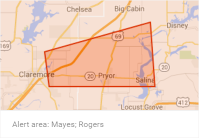
The following areas are affected.
Update (3/31/2016):
The tornado caused severe damage in the Tulsa and Owasso areas on Wednesday. The storm is expected to push eastward on Thursday, towards northern Mississippi, northern Alabama and western Tennessee.